A Travel Guide to Valley of Fire State Park
Located just 50 miles northeast of Las Vegas, Valley of Fire State Park is Nevada’s oldest and largest state park, covering nearly 46,000 acres of stunning red sandstone formations, ancient petroglyphs, and diverse desert landscapes. Named for its vibrant Aztec sandstone that glows like fire under the sun, this Mojave Desert gem offers breathtaking vistas, short hikes, and a rich history dating back thousands of years. Whether you’re a hiker, photographer, or road-tripper, this guide will help you plan an unforgettable visit to this geological wonderland.
Why Visit Valley of Fire State Park?
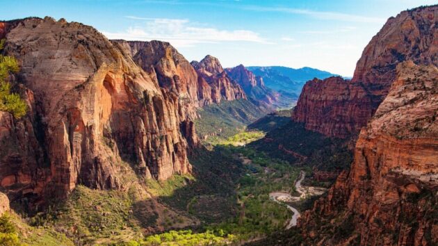
Valley of Fire is a must-see for its dramatic red rock formations, formed 150 million years ago from shifting sand dunes, and its cultural significance, with 2,500-year-old petroglyphs from the Basketmaker and Ancestral Puebloan cultures. The park’s compact layout makes it ideal for a day trip, with scenic drives, easy hikes, and iconic landmarks like Fire Wave and Elephant Rock. Its proximity to Las Vegas and unique Martian-like landscape make it a perfect escape from the city’s glitz, offering adventure and serenity in equal measure. The park has earned a Tripadvisor Travelers’ Choice award for its consistent high ratings and stunning scenery.
How to Get There
Valley of Fire State Park is located at 29450 Valley of Fire Hwy, Overton, NV 89040, about an hour’s drive from Las Vegas. Here are the main ways to reach it:
By Car from Las Vegas (West Entrance): Take I-15 North from the Las Vegas Strip for about 35–40 miles, then take Exit 75 (Valley of Fire/Lake Mead). Follow Valley of Fire Hwy for 17 miles to the West Entrance. Travel time: ~50–60 minutes. This is the most common route, with clear signage. Renting a car is recommended for flexibility, costing ~$30–50/day.
By Car from Lake Mead (East Entrance): For a scenic route, take I-15 North to Lake Mead Blvd, then follow NV-166 (Lakeshore Rd) and NV-167 (Northshore Dr) to the East Entrance via Lake Mead National Recreation Area. Note: A $20 fee applies for Lake Mead unless you have a National Park Pass. Travel time: ~60–75 minutes.
By Guided Tour: Several Las Vegas-based companies offer day tours, including transportation and guided hikes, for ~$100–150 per person. Check operators like Scenic Las Vegas Tours for options.
Public Transport: No public transit directly serves the park, so a car or tour is necessary.
Tip: Fill up your gas tank in Las Vegas or Overton (11 miles away), as there are no fuel stations in the park. Cell service is spotty, so download maps offline (e.g., from parks.nv.gov).
Best Time to Visit
October–March: The best months for comfortable weather, with daytime temperatures of 60–75°F (15–24°C). Winter nights can dip to 30–50°F (3–12°C). This period avoids extreme summer heat and trail closures.
Summer (May–September): Temperatures often exceed 100°F (38°C), and some trails (e.g., Fire Wave, White Domes) close from May to October due to heat. If visiting, go early in the morning and bring ample water.
Sunrise/Sunset: The red rocks glow most vividly at these times, ideal for photography. Avoid midday for softer light and cooler temperatures.
Crowds: Weekdays in spring or fall are less busy. Avoid peak times like Memorial Day or National Day holidays for fewer crowds.
Tickets and Opening Hours
Opening Hours: Park: Open daily from sunrise to sunset. Campers have 24-hour access to campgrounds. Visitor Center: Open daily from 9:00 AM to 4:00 PM.
Entrance Fees: Nevada residents: $10/vehicle/day. Non-residents: $15/vehicle/day. Bicycles: $2/bike. Annual Nevada State Parks Pass: $100 (entry only) or $250 (includes camping). Payment: Cash or card at the entrance booth or self-pay stations (exact cash needed).
Camping Fees: $20/night (Nevada residents) or $25/night (non-residents). RV sites with hookups: Additional $10/night. Group campsites: Available by reservation for up to 45 people.
Tip: Reservations are required for camping (via Reserve Nevada) and group sites. Day-use visitors don’t need reservations.
What to See and Do
Valley of Fire is packed with short, accessible trails and viewpoints, most reachable via the Valley of Fire Scenic Byway (11 miles) or Mouse’s Tank Road (5.7 miles, also called White Domes Road). Here are the highlights:
Scenic Drives: Valley of Fire Highway: This 10.5-mile Nevada Scenic Byway runs east-west, passing landmarks like Seven Sisters and Elephant Rock. Mouse’s Tank Road: A must-drive for its photogenic red rock vistas. Stop at pullouts for Instagram-worthy shots, especially near Rainbow Vista at sunset.
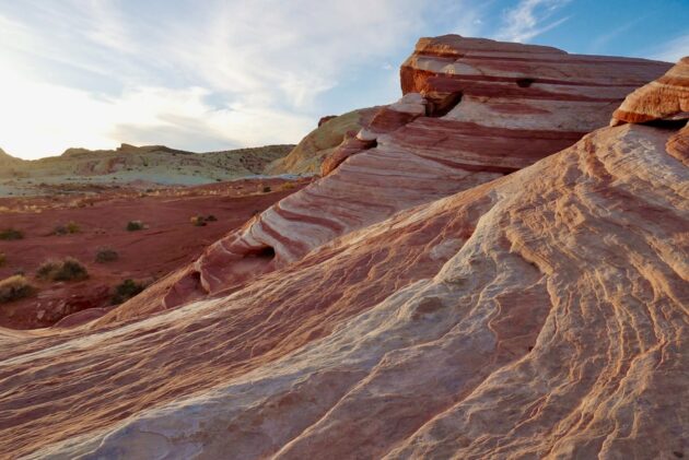
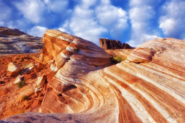
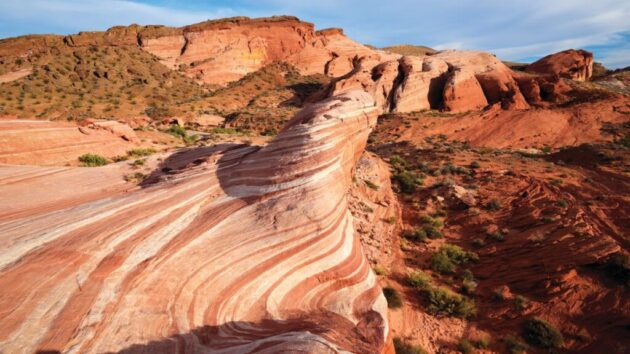
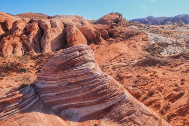
Top Hikes: Fire Wave Trail (1.5 miles round-trip, easy): Known for its stunning red and white striped sandstone, resembling ocean waves. Closed May–October due to heat. Best at sunrise for photos. Mouse’s Tank Trail (0.75 miles round-trip, easy): A flat, sandy trail with over 800 petroglyphs, the largest collection in Nevada. Named after an 1890s outlaw hideout.
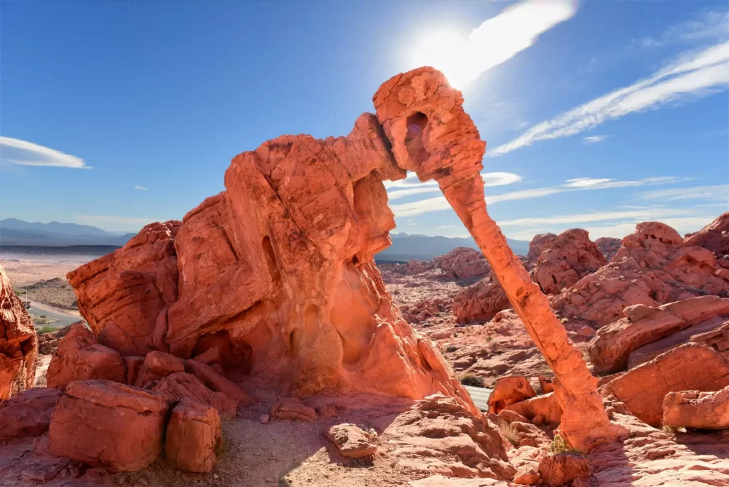
White Domes Trail (1.1 miles round-trip, moderate): Features a slot canyon, colorful rocks, and remnants of a 1960s movie set. Closed May–October. Elephant Rock (0.2 miles round-trip, easy): A short trail near the East Entrance to a rock formation resembling an elephant.
Atlatl Rock (0.1 miles, easy): A quick climb to view ancient petroglyphs, including an atlatl (spear-throwing tool). Note: Trails can be sandy/rocky, and markings may be unclear. Check with rangers and use apps like AllTrails for navigation.
Photography Spots: Rainbow Vista: A panoramic viewpoint with multicolored sandstone, ideal for sunrise/sunset shots. Fire Canyon Overlook: Offers dramatic views of red rock cliffs. Beehives: Eroded sandstone formations resembling beehives, great for creative shots. Tip: Drones are prohibited in the park.
Historical Sites: Petroglyphs: Found at Atlatl Rock, Mouse’s Tank, and other areas, these 2,500-year-old carvings offer a glimpse into Native American history. Do not touch to preserve them. The Cabins: Historic sandstone cabins built by the Civilian Conservation Corps in the 1930s, now a picnic area. Visitor Center: Features exhibits on geology, ecology, and history, plus a gift shop with maps and souvenirs. A must-stop for first-time visitors.
Other Activities: Picnicking: Shaded areas with tables and grills at Atlatl Rock, Seven Sisters, The Cabins, Mouse’s Tank Trailhead, and White Domes. Camping: Two campgrounds (Atlatl and Arch Rock) with 72 sites, offering shaded tables, water, restrooms, and RV hookups.
Equestrian Use: Horse trails are available; check with the Visitor Center for details. Weddings: Scenic spots like Seven Sisters and Rainbow Vista host weddings for up to 100 guests. Contact Scenic Las Vegas Weddings.
Accessibility Note: Many viewpoints (e.g., Seven Sisters, Rainbow Vista) are accessible from parking lots, making the park ideal for those with limited mobility. About 80% of the park’s beauty can be seen from roadside stops.
Where to Eat
In the Park: No restaurants or stores are available. The Visitor Center sells snacks and drinks, but bring your own food, water, and coals for BBQ grills at picnic areas.
Nearby: Overton (15 miles away) has diners and convenience stores. In Las Vegas, options range from fast food to fine dining.
Tip: Pack a cooler with lunch, snacks, and at least 1 gallon of water per person, especially in summer.
Where to Stay
Camping in the Park: Atlatl and Arch Rock Campgrounds: 72 sites with tables, grills, water, and restrooms. RV sites with hookups available. First-come, first-served until 2023; now reservable online via Reserve Nevada. Costs $20–35/night. Group Campsites: Three sites for up to 45 people, by reservation only.
Nearby Hotels: Overton (15 miles): Budget options like North Shore Inn at Lake Mead ($80–120/night) or Plaza Motel ($60–80/night). Las Vegas (50 miles): Wide range of accommodations, from budget (e.g., Motel 6, ~$50–80/night) to luxury (e.g., Bellagio, ~$150–300/night). Book via Booking.com or VRBO. Mesquite (40 miles): Casino resorts like Eureka Casino Resort (~$100–150/night).
Tip: For a day trip, stay in Las Vegas for convenience. For a multi-day visit, camping in the park offers a unique desert experience.
Tips for a Great Visit
Prepare for Heat: Summer temperatures can hit 120°F (49°C). Bring sunscreen, hats, and sturdy hiking shoes. Hike early or late to avoid heat exhaustion. Stay on Trails: Protect the fragile desert ecosystem and avoid disturbing plants, rocks, or artifacts.
Wildlife: Watch for bighorn sheep, especially near limestone mountains at dawn or dusk. Keep pets on a 6-ft leash to avoid harm. Photography: Sunrise and sunset offer the best light for capturing the red rocks. Avoid harsh midday shadows.
Cell Service: Spotty at best, with some signal at entrances and White Domes. Download offline maps or use a physical map from the Visitor Center. Time Planning: A full day (6–8 hours) allows you to see most highlights. For a quick visit, focus on Mouse’s Tank Road and 1–2 short hikes (2–3 hours).
Combine Your Trip: Pair with nearby Lake Mead National Recreation Area or Red Rock Canyon (1 hour west) for a broader Southwest adventure.
Final Thoughts
Valley of Fire State Park is a geological and cultural masterpiece, offering fiery red rock vistas, ancient petroglyphs, and accessible trails that rival the Southwest’s national parks. Whether you’re driving the scenic byway, hiking to Fire Wave, or marveling at Atlatl Rock’s petroglyphs, the park delivers a compact yet unforgettable adventure. Its proximity to Las Vegas makes it an easy day trip, but its beauty will linger long after you leave. Plan ahead, pack wisely, and immerse yourself in this desert wonderland.
Happy travels!