A Travel Guide to Medicine Bow-Routt National Forest
Spanning nearly 2.9 million acres across southeastern Wyoming and northern Colorado, the Medicine Bow-Routt National Forest and Thunder Basin National Grassland offer a breathtaking tapestry of rugged mountains, alpine lakes, and vast grasslands. Known for its diverse landscapes, from the towering peaks of the Snowy Range to the rolling prairies of Thunder Basin, this region is a paradise for outdoor enthusiasts. Whether you’re seeking challenging hikes, serene camping spots, or thrilling winter sports, this guide will help you plan an unforgettable adventure.
Why Visit Medicine Bow-Routt National Forest?
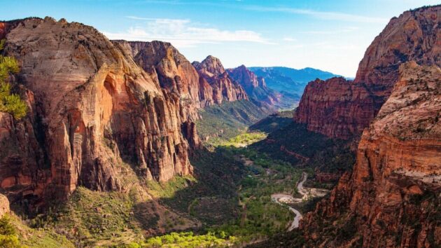
Medicine Bow-Routt National Forest is a haven for year-round recreation, offering everything from hiking and fishing to skiing and off-road adventures. The Snowy Range, with its iconic Medicine Bow Peak (12,013 feet), is a highlight, boasting stunning vistas and accessible trails. The forest’s diverse ecosystems support abundant wildlife, including moose, elk, and hummingbirds, making it ideal for nature lovers and photographers. Historical significance, like the Native American “medicine bow” gatherings, adds cultural depth. With fewer crowds than Yellowstone National Park, this region provides a serene escape into untouched wilderness.
How to Get There
The Medicine Bow-Routt National Forest is accessible from several points in Wyoming and Colorado. The primary access for the Wyoming section is via Laramie or Saratoga:
By Car: From Laramie, WY: Take Wyoming Highway 130 west (Snowy Range Scenic Byway) to reach the Snowy Range, about 30 miles (45 minutes). Exit 311 off I-80 leads to Snowy Range Road. Alternatively, Wyoming Highway 230 connects to Colorado Highways 127 and 125 for southern access. From Cheyenne, WY: Drive west on I-80 to Laramie (50 miles, ~1 hour), then follow Highway 130 into the forest. From Denver, CO: Take I-25 north to Fort Collins, then CO-14 or US-287 to Laramie (2.5–3 hours). Denver International Airport (DEN) is the closest major airport, 130 miles from the forest.
By Air: Laramie Regional Airport (LAR): Located 30 miles from the forest, it serves small regional flights. Denver International Airport (DEN): A 2.5-hour drive to the Snowy Range, ideal for international travelers.
By Public Transport: Public transport options are limited. From Laramie, taxis or ride-hailing services like Uber can get you to trailheads or campgrounds, but renting a car is highly recommended for flexibility.
Tip: The Snowy Range Scenic Byway (Highway 130) is a 29-mile route offering stunning views of alpine lakes and peaks. It’s open from late May to mid-November due to snow.
Best Time to Visit
Summer (June–August): Ideal for hiking, camping, and fishing, with mild temperatures (50–80°F) and wildflower blooms. Trails like Medicine Bow Peak are accessible, but higher elevations may see sudden weather changes. Fall (September–October): Vibrant autumn foliage and fewer crowds make this a great time for photography and hiking. Daytime temperatures range from 40–70°F.
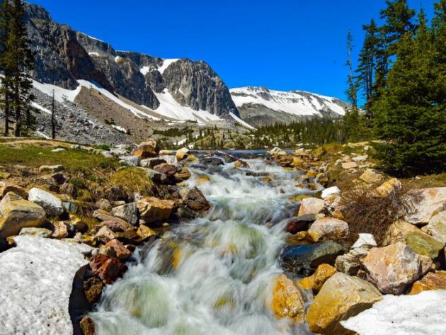
Winter (November–March): Perfect for snowmobiling, cross-country skiing, and snowshoeing, especially in the Snowy Range. Expect heavy snow and temperatures from 0–30°F. Highway 130 closes in winter. Spring (April–May): Snowmelt can make trails muddy, but lower elevations are good for early-season hiking. Weather is unpredictable, with possible frost.
Tip: Check weather and road conditions on the USDA Forest Service website (fs.usda.gov) before traveling, as high elevations can experience snow even in summer.
Tickets and Passes
Entry: Most areas of the forest are free to access, but some day-use sites (e.g., trailheads, picnic areas) require a Recreation Pass ($5/day or $30/annual). Purchase online at recreation.gov or at ranger stations in Laramie or Saratoga.
Camping Fees: Developed campgrounds like Sugarloaf or Brooklyn Lake charge $10–20/night. Dispersed camping is free but requires adherence to Leave No Trace principles.
Permits: Firewood collection permits ($20–40) are available for personal use. Hunting and fishing require Wyoming or Colorado state licenses, available at local retailers or online.
Tip: Print your pass and display it on your vehicle dashboard, as cellular service is spotty.
What to See and Do
The forest offers a wide range of activities across its diverse regions, with the Snowy Range being the most popular in Wyoming:
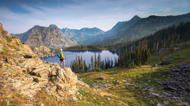
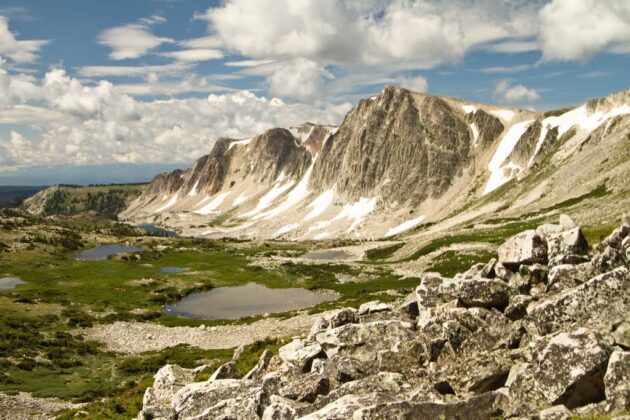
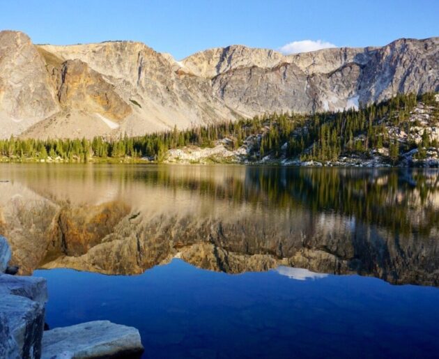
Hiking: Medicine Bow Peak via Lakes Trail Loop: A 6.7-mile, moderately challenging hike with 1,712 feet of elevation gain, offering panoramic views of alpine lakes and Medicine Bow Peak (4.8 stars on AllTrails). Takes ~3.5 hours. Gap Lakes Trail: A 6.2-mile trail with serene lake views, ideal for horseback riding and hiking. Laramie Peak Trail: A strenuous 9.7-mile hike (2,723 feet elevation gain) to the 10,274-foot summit, with views across multiple states.
Tip: Use AllTrails or the Motor Vehicle Use Map (MVUM) to find trails suitable for your skill level.
Camping: Developed Campgrounds: Sugarloaf Campground offers scenic views, hiking, and fishing nearby, though beetle-killed trees have impacted some sites ($10–15/night). Brooklyn Lake Campground is popular for its community vibe and proximity to rafting. Dispersed Camping: Allowed in most areas but not in designated wilderness zones. Follow Leave No Trace principles and avoid parking randomly (e.g., Greenrock parking area is not officially permitted for overnight RV stays). Cabins: Keystone Cabins in the Snowy Range offer a rustic stay near off-road trails, about an hour from Laramie.
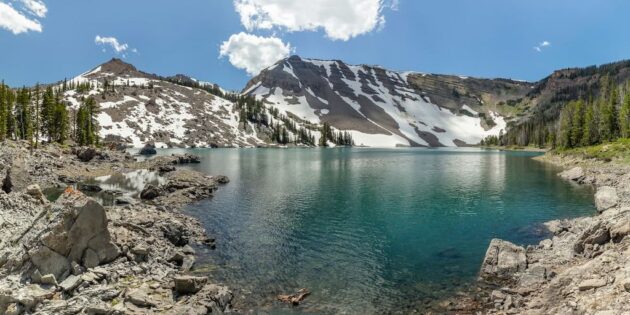
Scenic Drives: Snowy Range Scenic Byway: A 29-mile drive along Highway 130, climbing to 10,847 feet at Snowy Range Pass. Highlights include Lake Marie, Mirror Lake, and Libby Flats Observation Point, perfect for sunset views. Tip: Stop at the Laramie Visitor Center or Ranger District for maps and guides.
Winter Activities: Snowmobiling and cross-country skiing are popular in the Snowy Range. Albany Lodge (8,000 feet elevation) offers snowmobile rentals and trails in winter. The Snowy Range Ski Area provides downhill skiing and snowboarding, though it’s smaller than Steamboat Springs in Routt.
Wildlife and Photography: Spot moose, pine martens, and hummingbirds, especially near wildflower meadows. The Snowy Range’s rugged peaks and lakes like Lake Marie are ideal for photography. Tip: Bring a telephoto lens and practice safe wildlife viewing by maintaining distance.
Other Activities: Fishing: Lakes like Brooklyn and French Creek offer trout fishing. A Wyoming fishing license is required. Off-Road Adventures: Use designated OHV trails (check MVUM). Albany Lodge rents side-by-side vehicles for spring/summer exploration. Horseback Riding: Trails like Gap Lakes are suitable for equestrians.
Where to Eat
On-Site: No formal dining options exist within the forest. Pack food for picnics or camp cooking. Nearby towns offer better choices. Centennial, WY (15 miles from Snowy Range): Small eateries like Friendly Store & Restaurant serve burgers and comfort food (¥15–30). Laramie, WY (30 miles): Options include Sweet Melissa’s (vegetarian), The Crowbar & Grill (American), and J’s Prairie Rose (breakfast, ¥10–25).
Tip: Bring a cooler with water, snacks, and meals, as services are limited in the forest.
Where to Stay
Camping: Sugarloaf Campground: Scenic, with hiking and fishing nearby ($10–15/night). Brooklyn Lake Campground: Great for families and rafting enthusiasts ($10–15/night). Dispersed Camping: Free in most areas, but check regulations on fs.usda.gov.
Lodging: Albany Lodge (Saratoga, WY): A rustic retreat with cabins, a restaurant, and gear rentals, ideal for off-road and winter sports enthusiasts (¥100–200/night). Centennial, WY: Budget-friendly motels like Mountain View Historic Hotel (¥80–150/night). Laramie, WY: Chains like Hampton Inn (¥100–200/night) or budget hostels like Laramie Express Inn (¥50–100/night).
RV Camping: Developed sites like Sugarloaf lack hookups but are RV-friendly. Dispersed camping is allowed, but random pullovers (e.g., Greenrock) may violate regulations.
Tips for a Great Visit
Plan Ahead: Reserve campsites and check trail conditions on recreation.gov or AllTrails. The Snowy Range Scenic Byway closes in winter. Pack for Weather: High elevations (5,500–12,940 feet) can see snow year-round. Bring layers, sun protection, insect repellent, and a first-aid kit.
Respect Nature: Follow Leave No Trace principles—pack out trash, avoid disturbing wildlife, and stick to designated trails. Connectivity: Cell service is unreliable. Download offline maps and carry a printed Recreation Pass.
Combine Your Trip: Visit nearby Vedauwoo Recreation Area for rock climbing or Scotts Bluff National Monument (3-hour drive) for pioneer history.
Final Thoughts
Medicine Bow-Routt National Forest is a hidden gem offering rugged beauty, diverse activities, and a chance to connect with nature away from crowded tourist hotspots. From the majestic Snowy Range to the tranquil Thunder Basin grasslands, the forest caters to adventurers of all kinds. Whether you’re hiking to Medicine Bow Peak, camping under starlit skies, or snowmobiling through winter trails, this Wyoming treasure promises an unforgettable experience. Plan carefully, respect the land, and immerse yourself in the wild heart of the Rockies.
Happy travels!